
The Blackadder Walk from The Allanton Inn.
Whilst visiting family in the Borders, we popped into a local favourite of theirs for food: The Allanton Inn. I noticed a leaflet stand, which I normally ignore as it’s usually just local attractions, but since we’ve started doing more walks I’ve made a point to check for walking routes, as I’ve noticed more and more rural pubs seem to have their own, or locally produced, route suggestions. The Allanton Inn didn’t disappoint, and we found 2 walks – both of which we could do with the children – one 4 miles (‘Blackadder Walk’), and one 5 miles (‘Whiteadder Walk’).
Which one?
We arrived outside The Allanton Inn the next morning, ready for a walk. The weather was relatively warm, the sky mostly clear and blue, but the heat was barely noticeable with a very cool, extremely strong, wind! It’s been unusually blustery for the past few days, which isn’t always pleasant to walk in, but at least it was dry! 😅
We hadn’t yet decided which of the 2 walks we were going to do. One sees you turn left from The Allanton Inn, and for the other you turn right, so we asked the boys – they both wanted to go down the hill (right), so the Blackadder Walk it was! We met a couple of lovely chatty locals as we left too; one with 2 golden retrievers who recommended the Blackadder Walk, and even suggested a couple of others, and a lady who was keen for us to meet her spaniel, ‘Chive’ 😄! What a lovely, friendly, village!
Off we go!
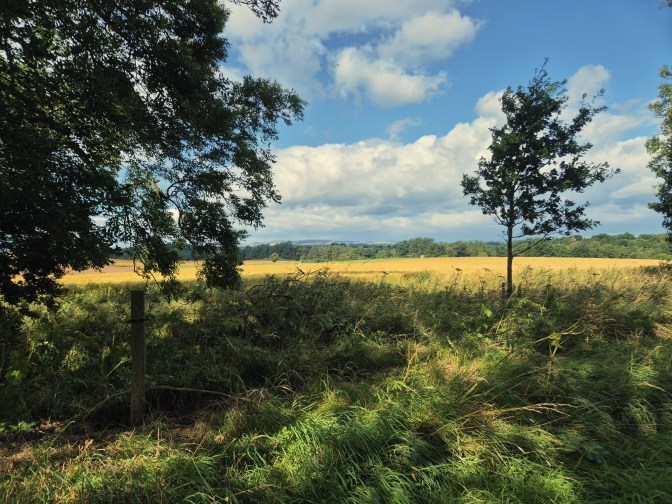
Once we’d met the local canine community, we headed off down the village toward the river. The walk, as I’d initially thought, doesn’t actually take you along the river, but along a lane to the left, just before you cross the main road’s bridge. There was no map on the walking notes, but the written instructions were actually some of the best we’ve ever followed, making good use of local landmarks to help keep us going in the right direction.

We followed the lane for around a mile, where we turned left at a beautiful, ornate building ‘Blackadder North Lodge’. Check out the stunning iron work and that amazing tiling!

This lane continued on for just over a mile, and past the old Butler’s House, ‘Blackadder Cottage’. The windows are concreted at the front, but the pathway was very neat, so I guess someone must still live here! Check out those lions on the parapet!

Halfway Round
Not far from the Butlers House was a large iron bridge, which took us over the Blackadder River again. On one side you can see the remains of Blackadder House, but with the trees full of leaves, none of us could see anything today. It was a very pretty little spot, though. If you’re walking with children, take care, the sides are fully open!


The walking notes suggested a small detour where you could see the old walled garden of Blackadder House, also now in ruins, along with Gardeners Cottage and the Summer House – these are apparently still standing but overgrown. However the route had a small sign saying PRIVATE so we thought it best to just continue onwards with the main walk.
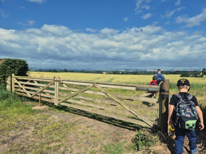
From the iron bridge we headed up the edge of a field of cows, fortunately with a fenced off pathway for safe passage. It would seem that local maps show alternative footpaths going off to your left, but the farmer has made it quite clear to follow his little arrows. Since these tallied up with the walks directions, it was of no concern to us.

After 2 cattle grids and a discussion about dry stone walls, we had made it up to Blackadder Mount Farm and onto the main farm track. Here we passed 2 lots of farm cottages – one of which once housed James Small, the brains behind the invention of the plough!

A Geocache!
At around the 3 mile point we were taken back off the farm track and returned to the fields.
At the first footpath sign, we had the chance to find our first geocache, too! It was a well hidden but easy find, fortunately, and the boys enjoyed checking out its contents. We signed the physical log, and the app log, then continued down the field.

This field was filled with wheat, but the next field had Peas! We’ve never walked through a pea field before! It’s quite common up here apparently – it’s lovely walking through different areas of the UK and seeing what food is grown where!


At the top of the pea field we hit a woodland area. The written instructions seemed to finish here, so we followed the edge of the woodland until we saw a clear pathway into the woods, with your usual footpath signs.
The Final Stretch
Immediately as you enter the woodland is a sign that warns of an unstable bridge and to not follow the arrows. We followed a clearly trodden alternative path instead – unfortunately it meant we couldn’t get to the only other geocache on this route.

This woodland used to be the East Drive to Blackadder House. I feel I’ve been so lucky this past week to have walked through so much woodland!

It wasn’t long before it opened up to the back end of a residential cul-de-sac, and within 5 minutes we were back at The Allanton Inn! Time for a coffee!
The Allanton Inn serves amazing food, as well as tea and coffee, if you just need a light refreshment. Children are welcome. You can eat inside, and dogs are welcome in the sheltered outside area.
Family Feedback: The Blackadder Walk.
This was a really lovely walk with lots of beautiful views across Chirnside and The Scottish Borders. It was also a nice easy walk, with a large chunk on a (relatively quiet) country lane, and very little in the way of difficult inclines or challenging terrain. The woodland section was a nice way to finish the walk, and overall it didn’t really feel like we’d walked 4 miles! The boys enjoyed the whole thing, and couldn’t pick a favourite part either! We really dropped on with the weather too, and found that a lot of the walk was quite sheltered from the wind. The clear sky meant we could enjoy far reaching views too.
If you’re interested in the history, here’s a link to Wikipedia’s details on Blackadder House. I’d have loved to have seen the ruins – it’s a shame at how they came about. It’s quite fascinating looking at all the old buildings we passed, and reading about their heritage. I found the walks directions not only accurate, but interesting, with short details of the buildings and who used them etc. If you find yourself in the area, I’d highly recommend you drop in to the Inn and grab a copy of the route!
TOTAL MILES: 4 | TOTAL TIME: 1h56 (1h37 Moving Time)
Discover more from Treks, Trails & Travel
Subscribe to get the latest posts sent to your email.

I had a friend who used to live in Paxton, near there so I’ve done a few walks in those parts.
LikeLiked by 1 person
How lovely! Any you recommend? 🙂
LikeLike
Coastal walk from Eyemouth to Coldingham (which a great beach) and there are some nice walks around Paxton House down by the Tweed
LikeLiked by 1 person
Brilliant, thanks so much! I’ll make sure we do at least one of these next time we’re up there 🙂
LikeLiked by 1 person