
When we made the first step to making walking a regular part of our life (a whole 4 months ago 🫣) I went and purchased the OS Maps Circular Walks book for our county. I thought this would make sure we always had inspiration on hand, however I hadn’t realised just how passionate my husband would get about all this walking: he downloaded the All Trails app, and has orchestrated most of our walks to date.
Some of the links in this post are affiliate links. If you click on them and make a purchase, I may earn a small commission at no extra cost to you. I only share links of products I have tried and tested myself, at my own expense. Thank you for supporting Treks, Trails and Travel family blog ❤️
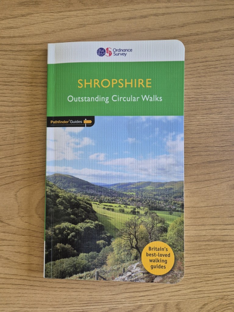
Feeling like we’d now exhausted all the circular All Trails options in our immediate area, I took the opportunity to dig the OS Maps book out again, and I’d like to try and do all the walks in this book over the course of the next 12 months. I’ll also be grabbing one for our neighbouring county and possibly even any other places we regularly visit, as I’ve been pleasantly surprised by the books.
The books are a decent size, measuring 22.9 cm x 13.6 cm. In a review, before I made the purchase, someone had described it as ‘pocket sized’. Now I know female clothing usually has ridiculously useless tiny pockets, but even so, pocket sized is not how I’d describe it! What it is though, is a great size for our waterproof map pocket. Open it up to your route and it fits beautifully inside (not quite so useful when the guidance goes over the page but it’s not the end of the world!).
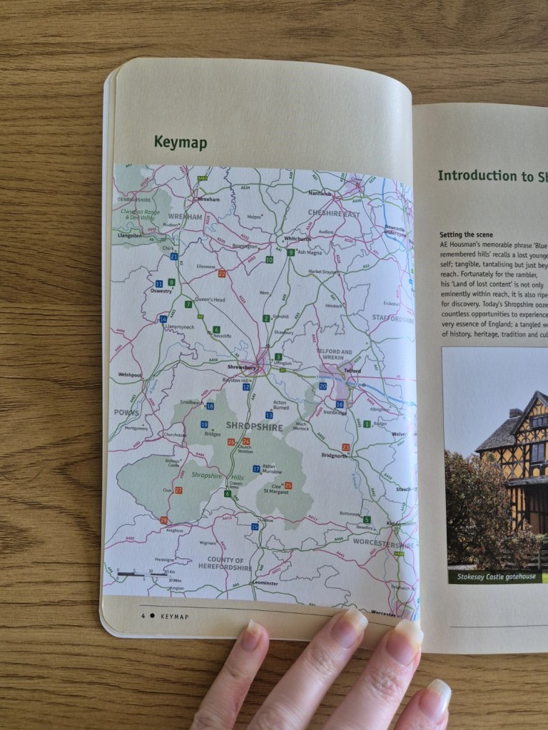
Inside is a key to the maps, and a helpful map of the county, with dots indicating the locations of each walk, along with a number so you can locate the information for that walk within the book.
There is also an “at a glance” section with the name of the walk, page number, location, length, altitude, estimated walking time and a short comment about the walk. Here they are separated into 3 groups: walks of less than 3 hours (green), walks of 3-4 hours (Blue), and walks of 4 hours or more (orange).
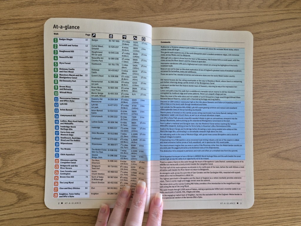
This is followed by a brief introduction to Shropshire, then we go straight into the walking guidance notes. Again, the walks are divided within this section using the same category’s they were in in the “at a glance” section.
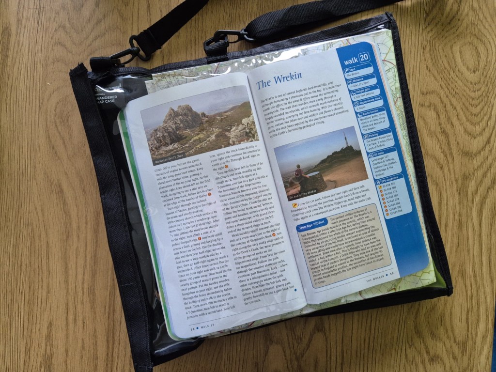
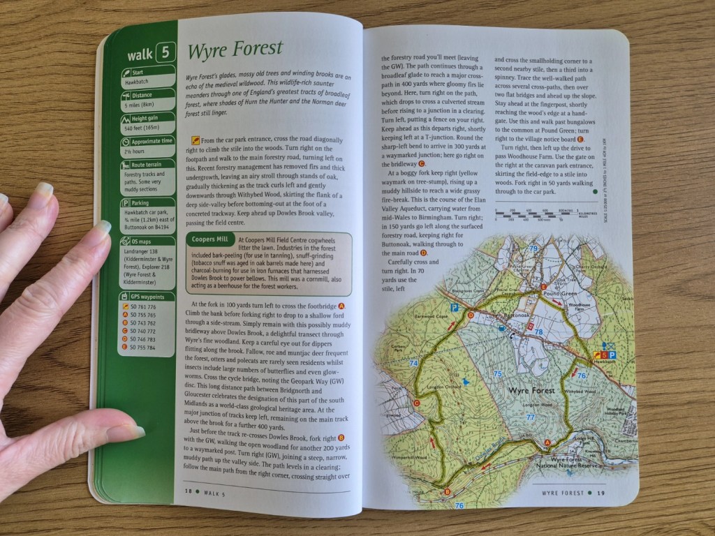
On the first page of each walk is a section which details the location, distance, height gain, approximate time, route terrain, parking, dog friendliness, OS maps and GPS waypoints.
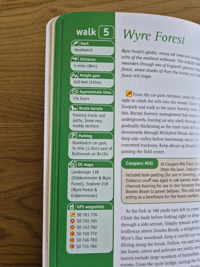
The directions are then written, interspersed with photos of scenery along the way, and interesting facts about the walk or the location. Within the text are helpful highlighted letters that indicate your location on the map – and are shown on the included OS map on the same page, with the route highlighted. I find this particularly helpful to work out where I should be, as the text is flowing, rather than having bulleted directions, which seems to send my head all in a jumble! It means I don’t have to scan all the text again to work out where I was, I just need to look for the letter I was last at and can easily match the text to the map.
At the back of the book are a couple of pages dedicated to Futher Information. This includes Walking Safety, Walkers and the Law, Useful Organisations then a list of all the relevant OS Maps for Shropshire.
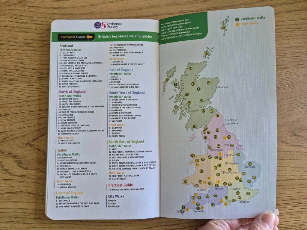
Right at the back is a map of the UK and a list of all the other books in the series. There are 80 of these books, which are part of the OS series of books “Pathfinder Guides”. Now, we jumped straight in for the “outstanding circular walks” (covers are green), because we prefer circulars to linears, but for those with smaller children, there is another series of 12 books (with yellow covers) that are filled with “great short walks for all the family” – I’ve yet to sample one, and if I do, I’ll let you know what I think, but if they’re as well laid out and informative as the circular walks series, I don’t think you’ll be disappointed!
Books are advertised at £12.99. We got ours from Amazon, and at the time of purchase it was £11.19.
The Walks
We plan to eventually walk them all (hopefully during the course of 2025), and as we do them, we will write our own posts about each walk, and let you know our thoughts, walking as a family.
Sub 3 Hour Walks
- Badger Dingle. To do.
- Grinshill and Yorton. To do.
- Haughmond Hill. To do.
- Nesscliffe Hill. To do.
- Wyre Forest. To do.
- Stokesay Castle and View Wood. To do.
- Maesbury Marsh and the Montgomery Canal. To do.
- Old Oswestry Fort. To do.
- Whixall Moss. A very enjoyable walk, but for smaller children there are a lot of smaller walks to do, and plenty to see. Read about our first walk to Whixall here, and our second, extended, walk here.
3-4 Hour Walks
- Racecourse Common and Offa’s Dyke. To do.
- Lyth Hill. To do.
- Acton Burnell. To do.
- Llanymynech Hill. To do.
- Ludlow, Mary Knoll Valley and Whitcliffe. To do.
- Ironbridge World Heritage Site. To do.
- Corve Dale and Wenlock Edge. To do.
- Snailbeach, Eastridge Wood and The Hollies. To do.
- Stiperstones. We haven’t done the exact route from the book yet, but we did do a great walk as documented here. We will be back to do the book’s route ASAP. An enjoyable walk, lots to see and climbing a plenty for children! Also a pram friendly route can be seen in the above blog post.
- The Wrekin. We have walked the Wrekin twice – but not yet done the route from the book! Walk 1 we took the right side, Walk 2 we took the left side. The OS book will take us on a longer version of Walk 2 – and we have several more Wrekin walks planned!
- Chirk Aquaduct. To do.
4+ Hour Walks
- Ellesmere and the Llangollen Canal. To do.
- Bridgnorth and the River Severn. To do.
- Caer Caradoc and Cardington. To do.
- Brown Clee Hill. To do.
- The Long Mynd. To do.
- Clun and Bury Ditches. To do.
- Knighton, Teme Valley and Offa’s Dyke. To do.
Discover more from Treks, Trails & Travel
Subscribe to get the latest posts sent to your email.

I like these books and I also have some AA walking books
LikeLiked by 1 person
I remember you mentioning the AA books, and I’ve got my eyes on some of them too 🙂
LikeLiked by 1 person
Think I’ve got book one and 26 somewhere, might have the Lakes one as well, haven’t got any of the others though
LikeLiked by 1 person
I think I will be collecting more as and when there are places we go, as I’ve enjoyed the layout and it’s given us some ideas on other places to walk that haven’t necessarily come up on my husbands All Trails app 🙂
LikeLiked by 1 person
we’ve a few of the Pathfinder series and I’ve done most of the walks in them. I’ll have to look and see if there is Circular walks one for Herefordshire
LikeLiked by 1 person